Last Trip of 3: May 2003
By David May
Cycle from Provence (Avignon) to Cannes or Nice on the French Riviera (Cote d'Azur)
Difficulty: Provence to Cote d'Azur via the Grand Canyon
of Verdon: Difficult
Ratings: Superlative
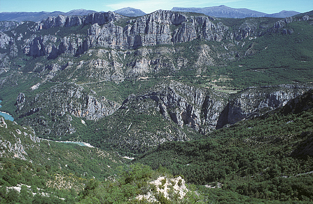
Below: View of the Gorges du Verdon from the south.
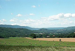
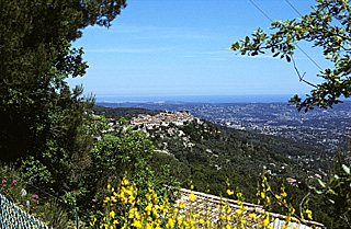
Below: Eastern Luberon valley with Grand Luberon Mountains
The author and a friend explored a route from Provence to the Cote d'Azur at Cannes during the May of 2003. It was a fabulous trip, suitable for bikers willing to tackle steep ascents in mountainous terrain. Highlights of the trip were the big sky countryside east of Manosque*, the town of Moustiers-Ste-Marie**, the Gorge du Verdon*** (deepest in Europe), and the Riviera hill towns***, and the descent to the Mediterranean at Cannes***. Details on the itinerary follow below.
The general route ridden by the author is the shortest, and, with one possible exception, is almost without traffic. It is also, the wildest, and one of the most beautiful European rides I have taken.
It would also be possible to take the much longer, much less mountainous, but fairly boring route from Provence to the Riviera: Manosque to Draguignan, and then continue southeast to the coast at St. Raphaël. The coastal route from St. Raphaël to Cannes and Nice would be beautiful and interesting. Or from Draguignan, one could turn northeast in the duller interior to Fayence, but would have to cross a range of high hills before reaching the coast at Cannes or Nice. These routes would encounter much more traffic.
When to go: As for Provence, the late spring or fall. Even at elevation, the summers are very hot. In winter, there can be snow.
How to Bike it: Organize your own trip.
See the Provence Page for complete coverage of the beginning of the route, from Avignon to the Luberon.
Cycling from Provence to the Côte d'Azur— from Avignon to Cannes
Be sure and reserve lodging well ahead in Provence unless your callsto hotels indicate it is not necessary.
The itinerary below is designed to allow for seeing the incredible sights of these regions. For those riders who only wish to log mileage, days could be combined.
Maps: For the Roman Heartland of Provence: IGN Top100 Map #66, 1:100,000 "Avignon-Montpellier". For the Luberon as far as Moustiers-Saint-Marie: IGN Top100 #60 "Cavaillon, Digne-Les_Bains" 1:100,000; for the remainder of the trip to Cannes, IGN Top 100 #61, "Nice, Barcelonnette"1:100,000.
Or: For the entire area: Michelin #528 French Riviera (or #245 Provence Côte d'Azur—same map as #528), 1:200,000. (This one map has all of the information you need for the entire trip, but lacks the tiniest roads, and is slightly less clear than the IGN maps.)
Plus: For the descent into Cannes, Antibes, or Nice, IGN 3643 ET "Cannes, Grasse, Côte D'Azur", 1:25,000.
To print itinerary, select the text below, and choose 'print selection'.
Please follow this link for an explanation of the author's traffic ratings.
Author's recommended itinerary:
Day 1. Arrive and visit Avignon***: See the Provence page for details.
Day 2. Avignon*** (leave via D97), L'Ile-su-la-Sorgue, Fontaine-de-Vaucluse***, Gordes*. The route if flat as far as the Fontaine-de Vaucluse, then it climbs almost 300 meters (1,000 feet) to Gordes* in about 10 kilometers. Total ride via back roads, about 44 kilometers.
Or divide this day into two very short but pleasant ones, at L'Ile-sur-la-Sorgue. Or ride from Avignon*** to Arles*** on back roads, from Arles to St. Remy* via Les-Baux-de-Provence***, and from St. Remy* to Gordes* taking three days. See the Provence page for details.
Day 3: Gordes*, Roussillon*, Ménerbes*, Lacoste, Bonnieux*. From Ménerbe* to Bonnieux* follow the Luberon Bicycle Route (see details on Provence page). About 35 or 40 kilometers, depending upon the route taken with several long climbs..
Day 4: Bonnieux*-Apt-Manosque, stopping at villages along the way (about 60 km without side trips). Follow the Luberon Bicycle Route as far as Céreste. Ride on the main road to the intersection of D907 just south of Reilanne (or you might want to follow the bike route to Reilanne, before turning south). Climb to a pass (Col du Montfuron) at 649 meters (about 2,000 feet), and descend without pedaling for 7 kilometers into Manosque*. The old town is worth a visit. Traffic is light to medium surrounding the old town, very light within it, but heavy on D907, where you will ride tomorrow, leading down from the city to the autoroute.
Day 5: 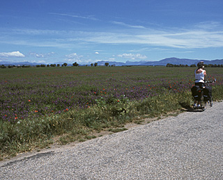 Manosque* (crossing the river and onto D6), long
climb and then flat to Valénsole (food available in the morning),
D56 (fair surface but almost no traffic to Puimoisson. The entire plain,
with lavender fields and distant mountain views, is exposed to sweeping
winds. Hope they are not against you. Continue on D56 to D952. Left turn
to Moustiers-Sainte-Marie**. (Total distance is about 50 kilometers).
Manosque* (crossing the river and onto D6), long
climb and then flat to Valénsole (food available in the morning),
D56 (fair surface but almost no traffic to Puimoisson. The entire plain,
with lavender fields and distant mountain views, is exposed to sweeping
winds. Hope they are not against you. Continue on D56 to D952. Left turn
to Moustiers-Sainte-Marie**. (Total distance is about 50 kilometers).
An alternative route from Manosque*, after crossing the Durance River, is to turn southeast on D4 and D8, crossing a high ridge, to Grénoux-les-Bains*, and following D952 northeast through Riez to Moustiers-Sainte-Marie** (about 50 kilometers). This route has much more traffic, but is shielded from north winds, and has bigger towns. Consider a rest day in charming Moustiers-Sainte-Marie**.
Day 6: Moustier-Sainte-Marie**, Corniche Sublime of Grand Canyon*** of Verdon (south rim) , Comps-sur-Artuby . About 64 kilometers with one very long climb (710 meters, or 2,330 feet in about 13 kilometers or 8 miles) and many lesser climbs...some wonderful descents too, and great views with the sun behind your back. Or, alternatively, take the easier northern corniche to Castellane* (about 45 kilometers).
Day 7: Comps-sur-Artuby) via D21 to the Route Napoleon N85 or from Castelane* just take the Route Napoleon), and from there to to Cabris and/ or Grasse. (50 to 55 kilometers). There are several moderately long climbs (and a large one out of Castelane), but most of the Route Napoleon, and almost all the last 13 to 17 miles of it is downhill. (Strongly consider blocking your lane by riding in the middle of it; on the right there is no shoulder and a major drop-off -- so there would be risk a car might try to pass you too closely.) . (About 60 to 65 kilometers via the detour.)
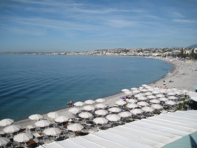
Day 8: Descent from Cabris* or Grasse** to Cannes*** or Nice*** on the Côte d'Azur*** (26 kilometers in traffic to Cannes***, about 55 kilometers to Nice with very little traffic after the first 4 km from Grasse).
View of Mediterranean from Cabris:
 The author suggests on weekdays and Saturday a start about 7:00 AM or at 9:00 AM, and on Sundays before 9:30 AM
to avoid as much traffic as possible. An alternative if you wish not to ride is to take the train that runs relatively frequently from the rairoad station in Grasse to Cannes and on to Antibes, Nice and Menton. (Grasse is located on the flanks of a steep hill, and has many one-way streets, so check a map of Grasse carefully before riding to the train station or ask for directions.)
The author suggests on weekdays and Saturday a start about 7:00 AM or at 9:00 AM, and on Sundays before 9:30 AM
to avoid as much traffic as possible. An alternative if you wish not to ride is to take the train that runs relatively frequently from the rairoad station in Grasse to Cannes and on to Antibes, Nice and Menton. (Grasse is located on the flanks of a steep hill, and has many one-way streets, so check a map of Grasse carefully before riding to the train station or ask for directions.)
For either Cannes or Nice: From Cabris, D4 descends to Grasse and comes to a traffic circle in Grasse (about 5 km).
Cycling from Grasse to Cannes:
(about 21 mainly downhill kilometers in traffic)
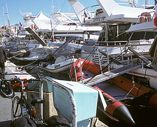
Yachts in Cannes
Turn sharply right at the traffic circle heading down hill, shen the road curves to the left at a traffic island, bear sharply left, continuing downhill in traffic. Cross a large traffic circle with a modern building on the left (sign: A8, Cannes). In about 3 km after the first traffic circle you arrive at the busy "Quatre Chemins" traffic circle. The first exit at the traffic circle n (which you do not take) leads to a four lane highway to Cannes. and on busily to Pegomas. You want the second exit, a minor road marked ''Les Aspres, Hospital Clavary". (The exit beyond this, N2085, which you do not want, is the busy Route Napoleon, also for Cannes). Stay on this same road, almost always downhill after itjoins D209 until it ends in the town of Pegomas at D9. Turn left on D9 towards La Bocca. Be sure to bear left, still on D9, when it veers off the main route. At the end of this road you reach N7, which you can follow left into Cannes, but a more enjoyable and fitting route (with more traffic)is to take the first available right turn, passing under the rail line, turning left on N98 along the shore. The sholder is not always available, so you should be prepared to block your lane if need be. Follow the Mediterranean into Cannes***. The Railway station is about 5 blocks in from the coast, behind the Palais des Festivals, which is just after the Old Port.
Cycling from Grasse to Nice:
(about 55 easy kilometers, mainly light trafic or bike path, mainly downhill)
Nuce bay from near end of bike path, which follows the line of the beach. Nice airport, which you will have passed, is visible at the far left in front of the green hils:
At the traffic circle where descending D4 from Cabris ends in Grasse, go left, onto a flat section of the road with a park on the right. At the next traffic circle, bear left, climbing slowly on the picuresque main street of Grasse. Continue straight at the next traffic circle on the level road. Immediately after a short one-way section takes you to the right, bear left, staying on the same level (sign "Nice"). Do not descend towards A8. Continue on this main road for Nice in light to medium traffic (except rush hour) for about 3 km through Magagnosc to a major roundabout in the shopping area of Pré-du-Lac.
Here, if you were to follow the signs to Nice (to the right), you would ride in increasingly severe, congested traffic until you hit the bike path in Villeneuve-Loubet. Therefore I strongly suggest that you follow the somewhat longer, almost always downhill, almost traffic-free route that follows:
Turn left at the roundabout (third exit) following the signs to Bar-sur-Loup. (The road to its left,marked "Gourdon", climbs 400 meters to the villageof Gourdon* with a superlative view from the Loup gorge to the sea.) This smooth road is continually downhill, with lovely views. Continue descending through Bar-sur-Loup to Pont-de-Loup, 6.5 km from the traffic circle.. Shortly after crossing the Loup river bridge bear right onto a descending, almost traffic-free road for La Colle-sur-Loup. (Note: The road to the left just before this road leads up into the very scenic, narrow Gorges-du-Loup.) As you reach the outskirts of La Colle-sur-Loup, about 12 km from the bridge, a bike lane appears as the road climbs steeply out of the valley. At the top of this short hill, by a gymnasium, turn right into a bike lane on a minor road (with athletic fields on your left). The bike lane ends. Continue on this road through many curves until it finally comes to a T. Turn right. Shortly a bike path appears.
In the village of Villeneuve-Loubet watch carefully for where the bike path turns right. The lane leads to a pedestrian bridge over the Loup river, now a calm stream. After the bridge turn left (sign: "plage 5 km" ). (That is, 5 km to the beach!) A bike path starts up. Follow this until it reaches the Autoroute, which you cross under by passing a barrier on each side. The spaces through the barriers are narrow, and it might be necessary to get off your bike to pass. You emerge onto a quiet town street. Turn left and in less than a kilometer, at the crosswalk, cross the highway to the costal bicycle path.
Turning right (west) here would take you to Antibes (and eventually Cannes). Turn left. The wide bike path, mainly with great views of the Mediterranean, leads to central Nice in approximately 11 kilometers.
To List of Best European Bike Tours